


 Motorcycle riding is not an easy thing to learn; you need patience and a lot of courage. Besides the force within, you also need to understand all the sign which you encounter on the highway in order to know your route and stay safe. So, today we are going to talk about milestones and different colour of milestones you see on the Indian highway. Because before you set out to conquer Indian roads you need to know them.
History of stones:
 In India the earliest use of milestones was by Sher Shah Suri, he erected 'Kos Minars' or Mile pillars. These were erected on the main highways for the purpose of indicating distance. They were huge stones with distances carved onto them. They were the only source of distance measurement while travelling; as a result, they were pretty important. To unit displayed on them was “Kos”, it’s an ancient Indian unit of distance which equals 1.8 kilometres.
Origin of Numbers:
The distance displayed on the milestones is usually the distance between the Head Post Office of two cities. This point of the Head Post Office is also known as the “Zero Mile” of a city which indicates the geographical centre of a city and the post offices mostly are in the centre of the city as well. But with continuous urban constructions and deconstruction, many “Zero Mile” points have been displaced over the years. Recently one such "Zero Mile" point was discovered in Pune where a fruit vendor was using to set up his fruit shop. So to be precise the numbers on the milestone equals the distance between the Head Post Office of respective cities.
Not just numbers:
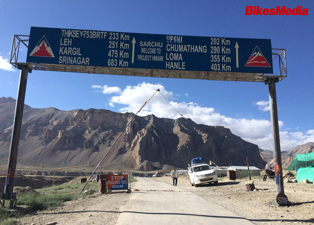
 Milestones not just speak about the distance between the Head Post Office of two cities, they also speak something with their colour. As it turns out different colour milestones represent different types of roads in India. The road can be a National Highway or Expressway, a village road, a State Highway etc. So let’s take a look at what Milestones speak with their colours:
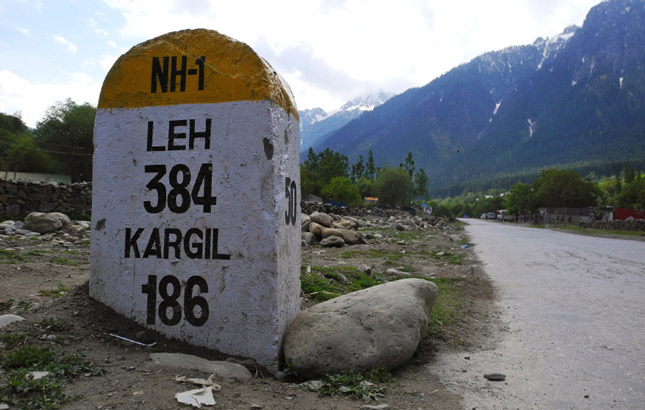
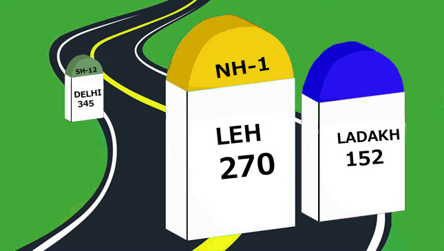
• Yellow and White milestone: This milestone indicates National Highway
• Green and White milestone: This represents State Highway
• Blue or Black and White milestone: This represents City or Main District Road
• Orange and White milestone: This represents Village road
• Green and White milestone: This represents State Highway
• Blue or Black and White milestone: This represents City or Main District Road
• Orange and White milestone: This represents Village road
 Conclusion (Bonus section):
Nagpur is also known as the “zero mile centre” because a Zero Mile Stone was erected by British, who used this point to measure distances to all the other cities. Nagpur was the geographical centre of colonial India. This centre has 4 horses and a sandstone pillar. On the pillar is a list which gives the exact distance by road of India's major cities from Zero Mile Centre.
Today when Google maps and satellite navigation has made it possible for us to travel almost anywhere that we want it’s unbelievable how far we have come from just a stone on the side of the road to a multi-billion satellite guiding us even in the most remote places on the planet. For all the adventure on two wheels, stay tuned to BikesMedia.
By: Yetnesh Dubey